Trekking to Everest Part Two Junbesi to Namche Bazar
Day Six Junbesi to Nuntala
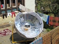
Put the Kettle on!
Heading out of Junbesi you cross over a bridge then take the routes heading upwards that lead into a forest before the path opens out onto bare hillside. On the map it looks like the path contours the ridge but in fact there is a lot of climb. You pass some houses and closed lodges before ‘turning the corner’ of the ridge at a collection of houses called Phurtyang, where there is a view of Everest on a clear day. No view on the day I was there but a good place for tea. The route then starts to descent, passing through a village called Sallung where I saw a solar water heater, that was going to be used for a baby’s bath. The path descends into forest again, weaving in and out of re-entrants before reaching a suspension bridge across the river. Then it’s a steep climb up to the village of Ringmo.
To the south you can see the village of Phaplu and its airstrip. Its from the south that the mule trains bring in goods that go up to the Khumbu. From now on the smell of Mule/Donkey or Yaks will be always in your nostrils.
To the south you can see the village of Phaplu and its airstrip. Its from the south that the mule trains bring in goods that go up to the Khumbu. From now on the smell of Mule/Donkey or Yaks will be always in your nostrils.
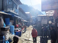
Nuntala 'High Street'.
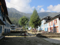
After lunch at Ringmo it’s a steep climb up a stepped path to the ridge of Trakshindo La at 3017m. At the top the path drops down to the village of Trakshindo which has a large monastery and some lodges. Now it’s a steep long descent on a wet path through forest. There were lots of birds to be seen in late afternoon. You pass some houses before eventually arriving at a suspension bridge that takes you to the village of Nuntala. This is a pleasant place with a ‘high street’ lined by lodges.
Day Seven Nuntala to Kharikhola
The path down from Trakshindo continues past Nuntala until you reach the bottom of the valley containing the Deku Kh river. It’s a steep, slippery descent which will take longer at than you think. At the bottom a suspension bridge crosses the Dudh Koshi River, this is the river which flows out of the Khumbu area and as you look north up the valley you are looking at your route for the next few days.
Across the bridge there is a short descent on a stepped path to the village of Jubing. I had lunch in a lodge here, it really is a lovely place filled with flowers, cultivation and butterflies. From here it’s another steep descent up to ridge which has tea houses at the top. From there it’s a pretty easy descent down to the spread out village of Kharikhola which has a couple of good lodges. This was a short day for me and many people continue on to Bupsa which can be seen on top of the ridge on the other side of the valley. It means a descent and a stiff climb at the end of the day if you do that. Kharikhola is quite a pleasant place to spend the night.
Across the bridge there is a short descent on a stepped path to the village of Jubing. I had lunch in a lodge here, it really is a lovely place filled with flowers, cultivation and butterflies. From here it’s another steep descent up to ridge which has tea houses at the top. From there it’s a pretty easy descent down to the spread out village of Kharikhola which has a couple of good lodges. This was a short day for me and many people continue on to Bupsa which can be seen on top of the ridge on the other side of the valley. It means a descent and a stiff climb at the end of the day if you do that. Kharikhola is quite a pleasant place to spend the night.
Day Eight Kharikhola to Puiyan (Paiya)
A short descent to the river and across the suspension bridge, but that’s it, the rest of the day is relentlessly upwards. There is a long slog then up the side of the valley to Bupsa, which seemed a nice place with some good lodges. The route now ascends upwards around the side of a large forested valley coming around to a end of a ridge which is called Khari La. Right on the end of it are a couple of tea houses and it was quite cold up there. The path now ascends less steeply and turns to follow the side of a very large valley containing the river Paiya Khola, on the far side of it you can see the village of Paiya spread along the path. The path continues in forest and the route is wet and slippery. This is one section where I was concerned as for most of the way, the path is next to a sheer, seemingly bottomless drop with very little to stop you falling all the way; a slip here could easily mean you are never seen again. You finally come to the river which is crossed by a bridge and the lodges begin soon afterwards. It depends how far you want to go as the lodges spaced out all along the valley side.
Day Nine Puiyan to Lukla
The path is now fairly level as it you head towards the end of the ridge where there is a tea shop. As you ‘turn the corner’ you have a good view up the valley to the Khumbu and Lukla perched on the side of the valley. It’s interesting watching the planes land on the airstrip, as it looks as if they are going to fly into the side of the valley.
The route now is a very long steep descent through forest down to the bottom of the valley and the small village of Surke, which is next to some rare flat land. You can bypass Lukla after Surke and continue onwards to the village of Cheplung. I found the path that leads up to Lukla, which is behind a house just after some Mani walls. The guide book makes it seem like it’s an easy hour up to Lukla, it isn’t. Firstly you climb up a steep ridge on a traversing path which then contours along into a small river valley with some houses in it, you’ll know it by the rubbish in it. There is then a long climb up the other side and into the outskirts of Lukla. By now the planes will seem to be landing almost on top of you and you will have to walk the length of the runway before finally arriving on main street Lukla.
The route now is a very long steep descent through forest down to the bottom of the valley and the small village of Surke, which is next to some rare flat land. You can bypass Lukla after Surke and continue onwards to the village of Cheplung. I found the path that leads up to Lukla, which is behind a house just after some Mani walls. The guide book makes it seem like it’s an easy hour up to Lukla, it isn’t. Firstly you climb up a steep ridge on a traversing path which then contours along into a small river valley with some houses in it, you’ll know it by the rubbish in it. There is then a long climb up the other side and into the outskirts of Lukla. By now the planes will seem to be landing almost on top of you and you will have to walk the length of the runway before finally arriving on main street Lukla.
Lukla
Lukla 'Main Street;
Lukla is quite a different place from what you’ve been used to. The path comes out next to the ‘Starbucks’ concession (I am not kidding) which is next to the Irish pub, there’s also a Scottish pub ‘though who knows why anyone would want to export that particular concept. Lodges range from the luxurious to the basic but the food on offer in the lodge restaurants is not much different from what you’ve been used to, although meat is on the menu. There are cafes with wifi and of course decent coffee, you can also buy a wider selection of goods than you’ve seen so far. The restaurants in the evenings are filled with groups having farewell dinners as they are at the end of their trips, saying goodbye to their guides and having the compulsory sing-along’s.
Day Ten Lukla to Monjo
From now on the trail is in much better condition, almost paved in some places and the route very easy to follow. You will also see many more trekkers than you’ve seen to date, with groups and individuals going in each direction. The quality of the lodges is better and generally you will pay more for everything
"Anyone got a shovel?"
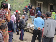
The path is flat all the way to Phakding, a large village where most groups stay after getting off the plane, the traffic thins out after that. The route then crosses the river (which looks like milk) and there is stretch of climbs and descents through forest. Lots of lodges and tea shops along the way. In the village of Toktok I saw a group of men who were debating about what to do with the body of a recently deceased horse. They’d built a wooden framework around the corpse which enabled them to pick it up and carry it along the trail before putting it down. I didn’t hang around to find out what they did do, dig a big hole?
The route crosses the river again with a couple of steep ascents and descents until you reach the village of Monjo, which is just outside the National Park. There is a TAAM checkpoint here, who will look at your trekking permit. There are some good lodges in Monjo.
The route crosses the river again with a couple of steep ascents and descents until you reach the village of Monjo, which is just outside the National Park. There is a TAAM checkpoint here, who will look at your trekking permit. There are some good lodges in Monjo.
Day Eleven Monjo to Namche Bazar
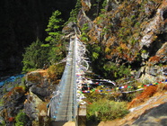
The suspension bridge.
Just outside Monjo is the National Park entrance where you will have to pay the entry fee of NR3000 to get in. The route crosses the river, passes through a village (Jorsale) where there is an Army checkpoint before crossing the river again. The path now goes beside the river before ascending up to a spectacular suspension bridge across a tributary to the main stream. Across this the path continues upwards through forest all the way to Namche Bazar, it’s a very long slog and it will be a real relief to see the outskirts of Namche.
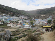
First view of Namche.
Namche. The town is in a natural amphitheatre, it’s as if a large scoop had been taken out of the mountainside and the town dumped in it. It’s large enough to be a town too with lodges and houses climbing up the sides of the depression. There’s a wide choice of places to stay, the usual Irish pub and lots of shops with reasonable prices for everyday goods. There are also a couple of banks which are occasionally open, one of which has an ATM which occasionally works. There are also lots of places selling outdoor kit. The menus are as uninspiring as ever but you can get meat. Not a bad place to spend a day and I spent most of my acclimatization day off taking advantage of the wifi which many cafes and lodges have.
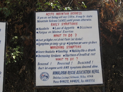
Sign at the National Park Entrance.
