Trekking to Everest - Part One. Jiri to Junbesi
There are two ways to get to the Kumbu, the Everest region, the route that most people take especially if they have little time is to fly to Lukla from the where the park entrance is only a days walk away. The second way is to walk the ‘Expedition Route’, the route that in the pioneering days everybody had to take if they wanted to see Everest, let alone climb it. This route has become shorter over the years as the road has been pushed further east but it still involves anything from four to ten days walking to get to Lukla.
These are my impressions and notes on my journey. I’m not a fast walker when carrying a weight (my backpack) especially uphill, so please don’t take my timings as any real guide, most people will move faster than me. If you’re tempted to write in to say ‘Ha, you wimp I did that in x hours’ don’t bother, trekking is not a race, everybody can go as fast or as slow as they like. The route moves across the land from west to east, and cuts across the grain of it, so you are continually climbing up from the bottom of one river valley up to a pass and then down the other side to the next valley. Most of the route is at around 2000 – 3000 meters although you do go higher, which should ensure you are fit and acclimatised by the time you get to the real mountains. I used the Trailblazer guide ‘Trekking in the Everest Region’ by Jamie McGuinness, which is a very good overall guide to the region.
These are my impressions and notes on my journey. I’m not a fast walker when carrying a weight (my backpack) especially uphill, so please don’t take my timings as any real guide, most people will move faster than me. If you’re tempted to write in to say ‘Ha, you wimp I did that in x hours’ don’t bother, trekking is not a race, everybody can go as fast or as slow as they like. The route moves across the land from west to east, and cuts across the grain of it, so you are continually climbing up from the bottom of one river valley up to a pass and then down the other side to the next valley. Most of the route is at around 2000 – 3000 meters although you do go higher, which should ensure you are fit and acclimatised by the time you get to the real mountains. I used the Trailblazer guide ‘Trekking in the Everest Region’ by Jamie McGuinness, which is a very good overall guide to the region.
Getting to Jiri
Getting to Jiri is an adventure in itself. There are several local buses that go early in the morning from the central bus station in Kathmandu. These really are local buses so don’t expect much comfort or for them to move fast as they will stop at every opportunity to pick up passengers until they are rammed full and practically sitting on your lap. At one point on my bus we even had a couple of goats and a basket of hens on board. The trip takes about ten hours plus. The route is similar to that which you will be walking over later, up and down, like travelling over a large sheet of corrugated iron. The road would be deemed an unregistered mountain lane back home, so overtaking is always a problem and there are few crash barriers. This is probably the most dangerous part of the trip. I did hear a rumour that there is a more comfortable mini bus that does this route, which is worth investigating (anyone know about this?) Don’t expect any help from the Themal travel agencies, they all want to get you on a private jeep at some ridiculous price.
Day One Jiri to Shivalaya
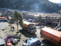
Jiri 'High Street'
After staying the night in a lodge at Jiri, where you are likely to meet some of the people you will be trekking with in the next few days, you set off along the road to Shivalaya, before branching off on a path that leads up to a ridge you can see on your left. I have to admit I got rather lost at the beginning and had an adventure being led by kind locals through fields before ending up at the top of the ridge which has a stupa on it. The guidebook is not much help here as lots of tracks have been bulldozed onto the landscape. When you get to the ridge follow the new track up to the top by a mobile phone mast before descending to a strung out village called Mali. You pass the village school which on the day I was there; they were having a prize giving. Follow the road down until it curves and cuts back on itself, on the corner there is a large house, the trail runs beside it and descends sharply. You then arrive at the river at the bottom, cross a couple of suspension bridges to arrive in Shivalaya. Shivalaya is connected by road to Jiri and buses do start from there if you are walking the other way. The road isn’t sealed and it’s not a trip for the nervous bus traveller, many people prefer just to walk to Jiri, the trekkers route being much shorter than following the road. There are lots of lodges in Shivalaya.
The next morning I and the other trekkers were called over to an office where a woman told us we had entered a National Park and we had to pay NR 2000, entrance fee! She gave me a long form so I could apply to enter! It seems that Shivalaya is in a park just about, you’re in it for about five minutes and the cynic in me makes me think that it’s included in order to extort money from trekkers. I didn’t pay it and nor did anybody else. I did register at the police post but they didn’t want to see my ‘park entrance’ or my trekking permit.
The next morning I and the other trekkers were called over to an office where a woman told us we had entered a National Park and we had to pay NR 2000, entrance fee! She gave me a long form so I could apply to enter! It seems that Shivalaya is in a park just about, you’re in it for about five minutes and the cynic in me makes me think that it’s included in order to extort money from trekkers. I didn’t pay it and nor did anybody else. I did register at the police post but they didn’t want to see my ‘park entrance’ or my trekking permit.
Day Two Shivalaya to Bhandar
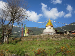
The stupas in the centre of Bhandar.
A steep climb out of Shivalaya and you will spend the morning climbing up to a ridge called Deoali which is at 2705m high and it has a small settlement on it. It’s a stiff climb up though rural Nepal, farm houses, famers ploughing terraced fields and lots of animals. A new road/track has been bulldozed up this hillside and you will cross it several times. I got to a level where I seemed to be at the same height as Deoali which I could see in the distance, so when I hit the road again I guess that it would contour to it gradually ascending. My guess was right so it was an easier walk in the end. I had lunch at Deoali, although you can stay here.
The route now descends steeply through scrappy forest before reaching the first houses that make up Bhandar. The centre of the village is around some stupas and there are some nicer lodges here.
The route now descends steeply through scrappy forest before reaching the first houses that make up Bhandar. The centre of the village is around some stupas and there are some nicer lodges here.
Day Three Bhandar to Kenja
The route descends here through the village until you cross a wooden bridge in a re-entrant. This is where the guidebook is now out of date as the locals have created a new route to Kenja. The old route went straight down to the valley bottom (where there is a bulldozed track) and then runs flat to Kenja. The new route contours around the valley side on a broad track, and is the route taken by the locals and porters. Don’t be tempted to climb up to the suspension bridge higher up the re-entrant, that’s the wrong way. There a few steep descents on the new route but otherwise is easy walking and should take about 2 – 3 hours to get to Kenja.
Here there is a police post where you must register, it helps to know you passport number at these places as they’re not bothered about seeing your passport. I stopped for the day here and took it easy having a pleasant time talking to travellers coming the other way. If you want you can have lunch here and then continue up to Sete which is halfway up the ridge in front of you.
Here there is a police post where you must register, it helps to know you passport number at these places as they’re not bothered about seeing your passport. I stopped for the day here and took it easy having a pleasant time talking to travellers coming the other way. If you want you can have lunch here and then continue up to Sete which is halfway up the ridge in front of you.
Day Four Kenja to Goyam
Now the screaming really starts as you now have to get up to the highest point on the trek, up to the ridge of Lamjura La at 3530m high. This is just under 2000 m of climb and most people take a day and a half to get up to the top. The route is obvious most of the way; there are no more roads now. The path climbs steeply up and again you are in rural Nepal and you pass through a couple of strung out villages. I got up to the hamlet of Sete for lunch; there are a couple of lodges here. The route is less steep after Sete as it ascends along the side of the ridge to a saddle in which there is a village called Dagchu, which has a couple of simple lodges. Two ponds mark the opposite ends of the settlement. The climb is now up through Rhododendron forest and as the cloud had rolled in during the afternoon it was a gloomy walk. The next place you reach is Goyem, which is strung out along the ridge. There are lodges here but they are very simple, and there’s no effort to entice you inside. I kept on walking until I came to a group of lodges together, which looked a little better.
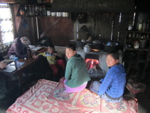
Simple lodge living is very simple. There’s no power and everything is done in one room and you will spend your time with the family in that room. Just like in earlier times in Europe, everything is based around the hearth, the fire that gives heat and light. The fuel is wood from the surrounding forest and despite it being quite cold, windows and doors are left open to let the smoke out. There is a hole in the top of the fireplace which is the cooking ‘ring’, no gas marks here, to get more heat more logs are fed in. The food you order will be cooked in front of you on the stove. Everyone, trekkers, kids, dogs and cats huddle around the fire. Outside is a pipe which is the only running water and the toilet is drop toilet in a hut at the far end of the yard. Not surprisingly, everyone tends to go to bed pretty early.
Day Five Goyam to Junbesi
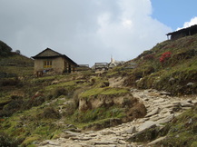
The top of Lamjura La
The path continues upwards for a while passing a couple of tea houses before it begins to level out and contours around heading directly for the pass at Lamjura La which you can see in the distance. It’s fairly easy walking to the top of the pass and you go by a couple of tea houses and a stupa. At the top of the pass is a tea house owned by a young couple. It’s a good place to have an early lunch, as the food is quite good and there’s not really anything on offer until you get to Junbesi. The path descends quite steeply through a very nice forest of coniferous trees, until the path levels out and you are back at the agricultural level. You walk on a sandy path that takes you past houses and through a small village before turning around an impressive rock that takes you into the valley that contains Junbesi. The path then descends to the village. With its brightly coloured corrugated iron roofs it reminds me of other remote settlements I’ve been to, and you could drop it anywhere from Iceland to Patagonia to Siberia.
Junbesi
This is a big village and sort of the half way point. As it came at the end of the ‘big climb’ and many people had told me it was a nice place I decided to have a rest day here. There’s a very nice lodge here called ‘Apple Garden Guest House’ which has its own orchard and the village has a hydro plant so there is actually electricity coming out of the sockets in the rooms; the lights are a bit dim though, I’m writing this in situ. Looking around the village, there are a lot of lodges which are closed and shut up. In many ways this has been the story of the route so far, a once thriving trekkers route which has gone into decline as more and more people fly into the Everest region. All along the trail, there are ‘lodges’ which have signs up with hotel names and menus who just don’t look like they’re geared up for visitors and would be surprised if you wanted to stay there. I was shown some pretty grim rooms and who knows how long it would take to rustle up a meal. What this means is that each village has probably one or two decent lodges which most trekkers head for. Usually the owner speaks good English and knows what trekkers want and they have an organized kitchen that can turn out
