Trekking to Everest Part 3 Namche Bazar to Everest
To continue the journey up from Namche Bazar, this is where the real mountains and high altitudes being. I in fact spent almost two weeks in the region and first went up to Gokyo before retracting my steps and heading up the Khumbu Valley to Everest. In order to maintain the narrative, I shall continue as if my journey was directly from Namche to Gorak Shep, the last in habituated stop before Everest.
For those who have come from Jiri there are quite a few differences. Lots more people, lots more Yak traffic and generally despite the altitude the trekking is easier. There are some big climbs but nothing compared to what has already been experienced, and the trail is well maintained. The route will be described from major centre to major centre and/or acclimatisation halt as against on a daily basis.
For those who have come from Jiri there are quite a few differences. Lots more people, lots more Yak traffic and generally despite the altitude the trekking is easier. There are some big climbs but nothing compared to what has already been experienced, and the trail is well maintained. The route will be described from major centre to major centre and/or acclimatisation halt as against on a daily basis.
Namche Bazar to Tengboche
While in Namche you will be able to see trekkers heading up what looks like a long ramp on the eastern side of the ‘basin’ the town sits in. You have to slog up to a path junction, one of which is signposted to the National Park HQ. Continue upwards to a collection of houses and a large rock which sits in the middle of the path. A route heads upwards to Syangboche but the path you need is to your right. Walk past some lodges and soon you are on a broad path that contours the hill, a trekking motorway. This marvellous path meanders up and down passing a couple of stupas. There is a great view of the valley you walked up from Lukla and the really big snow covered mountains come into view.
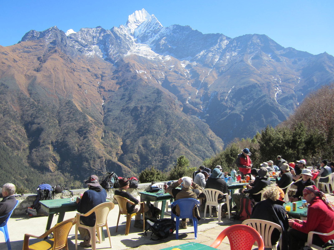
Chilling in Kyangjuma.
It should only take about an hour so reach the first settlement on the route, Kyangjuma, a nice place for a stop with Alpine type terraces to sit out on. From here you can see Tengboche on the hill across the valley and also the village of Phortse, a large village that sits on a ledge on the side of the valley. Its from here that the climbing Sherpas are recruited and most of the men work in the climbing industry.
The path then turns into a small valley and crosses a bridge before reaching Sanasa, which is also the junction for the route up to Gokya, this is well signposted. From here the path heads down through forest, with paved sections and a fairly easy descent. At the bottom of the hill is a suspension bridge across the river, on the other side are some tea houses and a small Army camp.
No getting away from it, the next section is tough, a long, steep and dusty slog up to Tengboche through forest. You emerge on top of the hill with a view of the Monastery and the lodges that surround it. It’s very pretty and interesting so linger and take some pictures. I didn’t actually stay here as there not many lodges and they seem to be the preserve of groups; so I walked on for another twenty minutes downhill through Rhododendron forest to Deboche, smaller but with some very nice lodges.
Tengboche to Pheriche/Dingboche
Dependant on where you stayed the night walk downhill to where the river is crossed by a suspension bridge. The route now gradually ascends up to the village of Pangboche, which is quite large with a lot of lodges. Before the coming of tourism this was the highest inhabited village, as nothing much grows higher up. From here the route is fairly level only gradually ascending up to the village of Shomare which is larger than it looks on maps with quite a few lodges. The path contours on until it reaches a junction at Tsuro Og, which is just a couple of houses. Here there is a confluence with rivers coming in from separate valleys and a bridge over one of the branches.
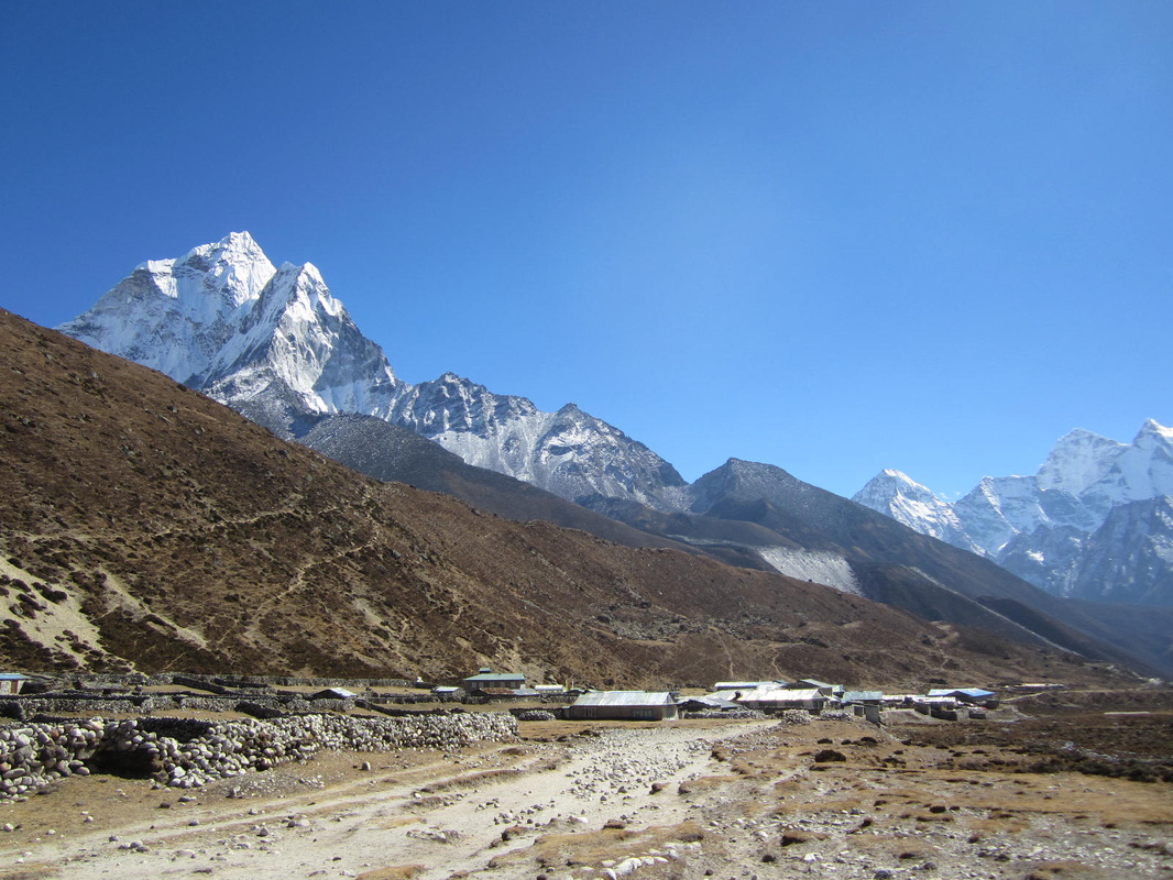
Looking back at Pheriche.
If you cross the bridge the route will take you around the side hill to Dingboche. I didn’t go there but it is favoured by groups as a place to stop and even stay the day to acclimatise. If you keep going ahead you will climb up the small Pheriche Pass (4270m) and then drop down to another bridge which takes you to Pheriche a large lodge village in a board valley. Apparently groups only stay here on the way down as it is thought to be a very windy spot, and not a place to linger. There are some pretty solid lodges here though and it’s a dramatic setting, like something out of the Wild West. You know you are getting closer to the ‘real’ mountains as you will have already have passed some memorials to climbers killed on them.
Pheriche/Dingboche to Dughla/Lobuche
Just how far you ascend in the next few days depends on how you are feeling. I met one woman who couldn’t get higher than Phercihe without feeling sick. There is a route from Dingboche which rises up on to the hillside before heading to Dughla. From Phercihe the route is a fairly flat run up the valley, easy although it can be wet underfoot. At the end of the valley the route then turns left up a much smaller valley, climbing steeply before joining the path from Dingboche, it then crosses a river on a metal bridge. On the other side of the valley is Dughla, which is only one lodge. As it happens I spent two nights here, one on the way up and one on the way down.
From the lodge the path ascends steeply up the snout of the moraine mass that has been pushed down by the Khumbu Glacier. At the top of this are a large collection of memorials to climbers killed on the mountains. The path levels out again then gradually ascends, heading up the valley formed between the hillside and the moraine wall of the glacier. On the right can be seen the path that comes in from Dzonglha and the route from the Cho La Pass.
Lobuche is another quite large lodge village, where it’s possible to stay or just have a meal, before making the final effort to reach the end of the valley.
Lobuche to Gorak Shep
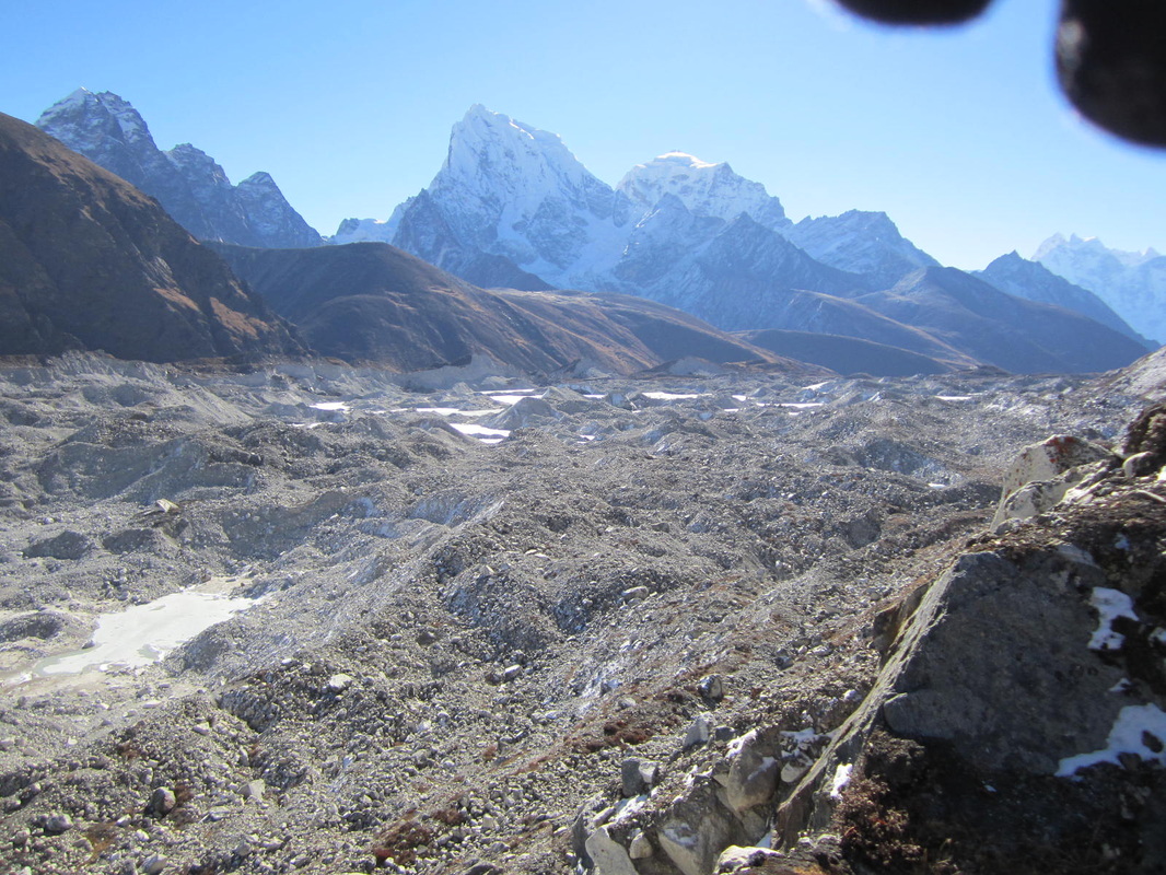
Khumbu Glacier
The route now ascends the valley, rocky underfoot but fairly easy going. You will see a sign to a side valley which houses the ‘Pyramid’, the Italian research station. Ahead you will see land rise up, this is the start of the moraine debris you will have to cross, which gets progressively more difficult and unstable. On the map the route crosses a glacier where the Khargri Nup Glacier and Khargri Shah glacier meet and feed into the Khumbu glacier, but don’t worry about that, because it isn’t there anymore. The path dips down into the valley cut by the ice which now has a fast flowing stream in it which is crossed by a small bridge. Looking up the valley you can still see large sections of ice, the remains of the glacier that used to be here; looking down at the Khumbu there are large lakes of water on the surface where the ice has melted. This is what global warming looks like and I’ve seen examples of it all over the world.
Gorak Shep
Climbing up the valley side you cross another section of unstable moraine, which needs to be crossed with care. Shortly afterwards you reach a rise and look down on the settlement of Gorak Shep. The buildings cluster around the hillside above a flat plain, with Kola Pattar rising up on one side, you’ll know it by the well worn paths going up its side.
If you’re an independent traveller you’d be well advised to get here early, as this is the one place you will have problems getting a room as most places are block booked by groups. Try to team up with someone if you’re on your own as they won’t give a room to a single person either. This is one reason many people come here and climb Kola Pattar and go to Base Camp as a day trip from Lobuche which is very feasible and you don’t have to stay the night at such a high altitude.
I didn’t go to Everest Base Camp as I couldn’t see the point as there is nothing to see there, not even the mountain, which you can’t see from Gorak Shep either. To get that grand Everest shot, with you in it, you have to climb Kola Pattar.
Kola Pattar
Most people in groups are hustled out of bed at 5 o’clock to climb Kola Pattar in order to see the sunrise over the mountains. I wasn’t one of them and I didn’t start climbing until 0730 when most people were coming down. The reason for this is that the view and the mountains are in the east, so the sun rises behind them, so at sunrise they will be silhouette, but you probably won’t see much detail. The best time is later in the morning when the sun is sufficiently high to ‘light them up’ but it’s too early to cloud over. If there’s no cloud then the best time of all would be at sunset, the light will be shining directly from the west.
I’ve never really understood this mania for seeing the mountains at sunrise, which is very much the norm in most of Asia. If you were to climb mountains in the dark at home you would be considered very odd or stupid, but when people are on holiday even the very experienced seem to go along with it.
The path starts steeply, then levels out before climbing steeply again. The route is well trodden and there are a variety of paths all of which lead up to a steep drop decorated with prayer flags with views onto the glacial valleys to the west. The summit is directly above you with a monument adored with more prayer flags and a weather station. A steep climb and you’re there. On the way up you would have seen Everest coming into view, at the top you can see the ice fall, the summit and just peaking over the flank of Lhotse, the south col. You’re at 5550m above sea level, soak it in, take you’re pics. If you’ve come with me from Jiri, you’ve worked very hard to get here, so savour the moment.
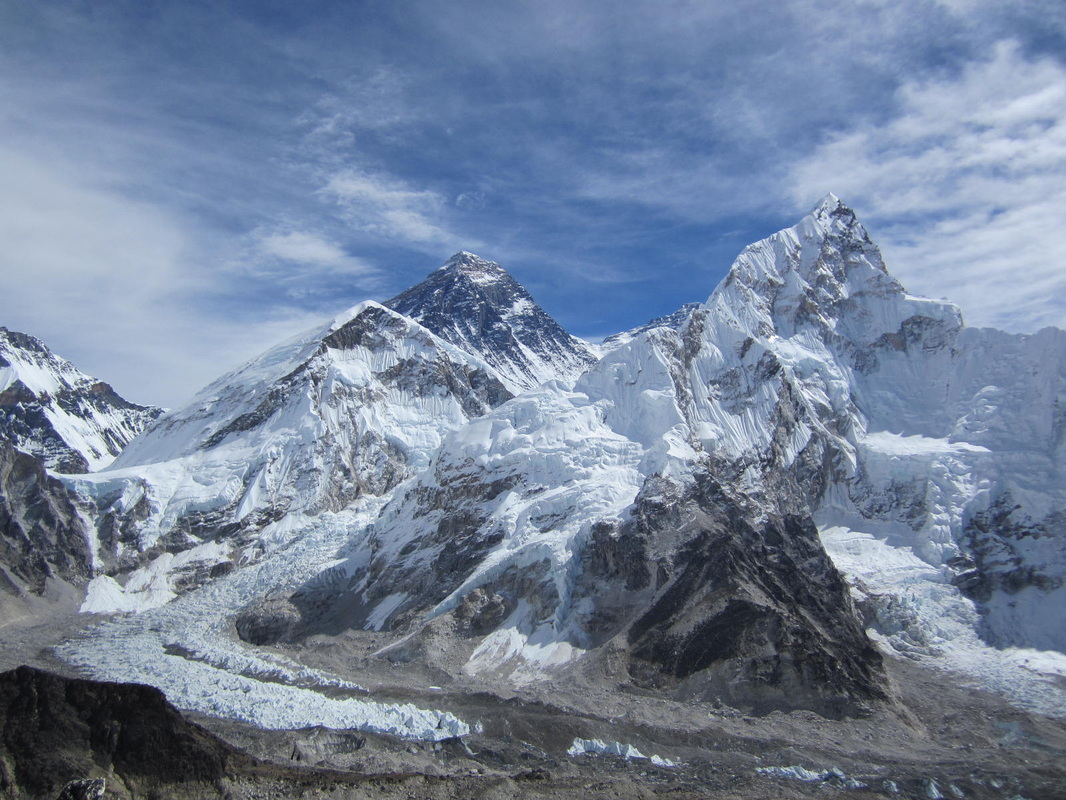
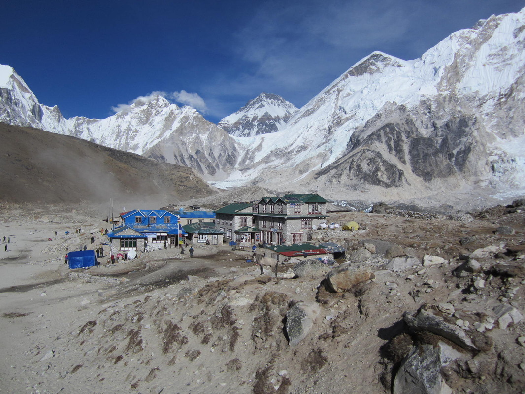
The Classic Everest view from Kola Pattar.
|

This could be you.
|
